The Cordilleras Blanca and Negra were such an incredible place in which to spend a few days, and we will hopefully be back for more some day. Then came the family visit - time to put on weight, blend in with the masses of tourists that visit Machu Picchu every day, and get our fitness levels back to almost zero. Finally, after nearly a month off, it was time to get back on our bikes and carry on South...
With lighter bikes and lots of enthusiasm, we planned what would be one of the most challenging rides of our cycling days...thanks to the great
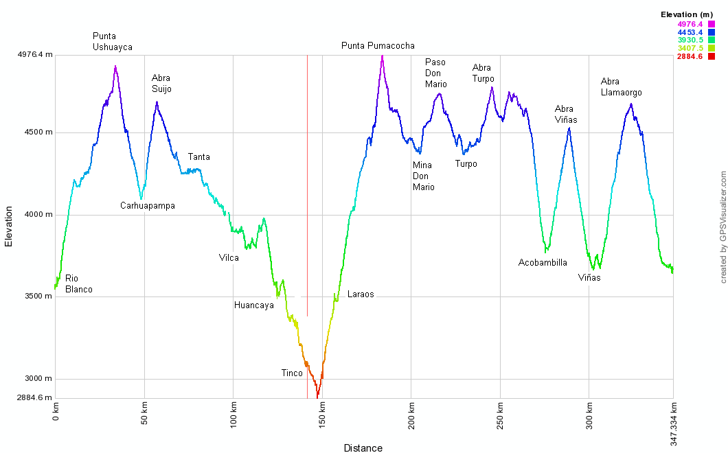
Andes by Bike website. The route would take us from Conococha, 80 km south of Huaraz, to the lovely colonial town of Huancavelica. Only 800 km (over 770 km of it unpaved) and no less than 13 passes over 4500 m separated us.
The
Pikes´ website is like no other...full of useful information, unpretentious and when coupled with their
blog made for a great guide to take on our route. The Great Divide name originates from the famous Great Divide mountain biking route of the US, which essentially separates the Western and Eastern watersheds (water drains to the Pacific in one side, to the Atlantic in the other). In Perú, that would be to the Pacific, and to the Amazon basin.
To our surprise, this incredible route not only would take us to wonderful places, but also allow us to interact with the most kind and friendly people of Perú to date. As it is still a relatively new route, most locals welcomed us into their villages, and told us stories about the previous passing cyclists, some of whom we´ve already met or heard of.
Below the story of the first half of the route...
 |
| The profile looks intimidating. No flat bits anywhere, and look at those small numbers on the Y axis! (taken from the Pikes´ blog) |
 |
| It´s election season in Perú - here with our lighter bikes (see the fancy frame bags and lack of front panniers!) |
 |
| A quick bash South on the main road, the sometimes dodgy Callejón de Huaylas, and we leave the mighty Cordillera Blanca in the background... |
 |
| Armed with the Pikes´audax-style routesheet, we felt at home. Except that this routesheet is for off-road riding that would take not hours, but days. |
 |
| The laguna Conococha (4100 m) marks the official start of the route. If you travel through here, avoid the food at the town at all costs! For the first time in eight months in South America, we met a soup that we just could not bring ourselves to eat (think unwashed intestines and stomach chunks floating around delivering a horrible smell...) |
 |
| After a short climb, we get the first views of the Cordillera Huayhuash, a place we would very much like to visit someday. |
 |
| And as it often happens in Perú, there may be no facilities in towns but there will always be mobile signal. In the background, the Yerupaja (6635 m, and the second highest mountain of Perú) overlooks the valley |
 |
| We then arrived in Ticllos and spot the beautiful church made by the Don Bosco association. Upon arrival, the major welcomed us, gave us a place to sleep in the municipality, and then Abraham (the treasurer) took us on a tour of the town. and a quick visit to the Dr so Alberto could get some antibiotics for his throat. Still don´t understand why some cyclists complain about the Peruvian hospitality... |
 |
| Before we knew it, we were cycling in the high Andes. |
 |
| It was a great feeling to finally be riding on the Great Divide. |
 |
| Most days, we were more concerned with animals in the road than cars. |
 |
| Then it was time to get low (1400m) one last time, down into a river valley. Llipa Viejo is the (abandoned) settlement that is pictured on the slope |
 |
| After camping in the under-construction sports stadium in Llipa Nueva, we descended for 44km, losing 2300m of altitude in the process -- with many stops to let the rims cool off... |
 |
| ... watching the scenery change as we went. |
 |
| After an annoying puncture for Alberto, we reached the bottom at the hottest part of the day, ready to start the 3100m climb that would take us two days to complete. |
 |
| On our way up, a passing gringo on a motorbike stopped to chat - he had done plenty of cycle touring in India, China and Nepal, so was very keen to hear our story. Not having enough time to cycle tour in Perú, he had jumped on a rented motorbike in Cusco, and was moto touring the quiet roads of the Andes. |
 |
| Halfway up the climb, the village of Yocchi had a really well-stocked shop (locally grown avocados) and even public (with a cold shower) restrooms we could use as we camped by the side of the road. |
 |
| After four days of riding, we reach our first sizable town of the route, Cajatambo, where we enjoyed an afternoon off. |
 |
| On the dirt roads, our new bike setup was really coming into its own. We dubbed it the "mullet setup" - business in the front, party in the back. |
 |
| Then it was time for our first of many high passes, Paso Pacomayo at 4540m. |
 |
| Under threatening skies, we set up camp at that day´s lowest point, 4300m. |
 |
| But in the morning, sunny weather was restored and we enjoyed another high-altitude day´s riding to Oyon. |
 |
Climbing again through a pampa...
|
 |
| ...we stopped in at the only facility in 2.5 days´riding, a small shop, and the owner´s son (whose name is Stalin, or so he said, we are not kidding) joined us for a few kilometers of towards the closed Mina Chanca. |
 |
| The approach to the mine featured a cemetery, presumably for the mine workers who had died on duty. |
 |
| Onwards we climbed towards Punta Chanca, passing beautiful lakes and colorful mountains as we went. |
 |
| All of the people we met on the road to Oyon (which is to say, two cars and a man on horseback) were incredibly friendly and stopped to chat. This guy got a real kick out of seeing us and insisted on taking a picture. |
 |
| We topped out at 4850m and enjoyed an awesome descent into the mining town of Oyon.... |
 |
| ...through a valley that looked like what you would see if you looked up the world 'valley' in the dictionary. |
 |
| Oyon wasn´t exactly the charming town we were hoping for, but it did have everything we needed, including ferreteria, bike shop, and a filling Chifa restaurant, complete with drunk man falling asleep on his plate. |
 |
| All the affordable hotels were either full, too gross to contemplate, or required climbing narrow stairs that couldn´t fit our bikes. So we asked in the church, and were given the meeting room of the parroquia for the night. |
 |
| From Oyon it was time to climb again (basically, every morning, it was time to climb again), past more mines -- looking at the colors of the mountains, it wasn´t hard to see why. |
 |
| We reached 4870m before a slight descent... |
 |
| ...and then another short climb... |
 |
| ....before finally reaching Abra Rapaz at 4940m, a new record for us. |
 |
| We descended into Rapaz, which was deserted as the entire village was watching a bullfight as part of the town´s fiestas. |
 |
| Then kept descending to the thermal springs of Huancahuasi, where a dip in the warm waters was the closest thing to a shower we´d get for a long time. The owner allowed us to camp in the field behind the hot springs, which seemed great until we learned the field was the late night hangout for about 20 curious donkeys and horses. Oh well! |
 |
| The following day, a short day to Parquin was called for. We always approach Sundays in Peruvian towns with a bit of caution, as it usually means large groups of drunk men in otherwise deserted towns. But the drunk men of Parquin were actually very friendly. Fernando (on the right) was a candidate for mayor (and not drunk) and invited us to his house for lunch, as there were no restaurants open on Sunday. |
 |
After a night sleeping on the floor of Parquin´s health centre, we started what was described on our route sheet as a ´brutal climb´. It sure was steep at times, although we didn´t suffer as much as we expected to.
 |
After a roadside camp we were up and over Abra Mio (4760m) in the morning...great views all around...
|
|
 |
...then enjoyed another thrilling descent...
|
 |
...before hitting what the Pikes´describe as "large and pretty" lake. Not only it feeds water to Lima, and generates some electricity for the Limeños, but also has a trout farm at the far end.
|
 |
| Going around the big lake pictured above, we met Alfredo, the trout farm owner who invited us in to his warm hut for a sorely needed hot drink. He and his son collect a mere 300-400 kg of truchas every Thursday that they then sell in Lima for S/.12 ($4.5) a kg! |
 |
We left Alfredo feeding his truchas while we tackled the last climb of the day, to Punto Punta Fierro Cruz (4820 m), an easy yet scenic one...
|
 |
| ...then camped at a chilly 4600 m. This is how we spend time in the tent, before falling asleep usually before 8 pm! |
 |
| The following morning we pedalled on towards the main Abra La Viuda-Huayllay road (which eventually goes to the famous Bosque de Piedras). As we were approaching the end of the dry season in Perú, and soon in Bolivia, we decided to carry on and skip the Bosque until we return to this wonderful part of the world... |
 |
| ...then were amazed at seeing solar panels and cable TV in this rural estancia...sometimes Perú surprises you! |
 |
After 2.5 days eating "camping" food, we were aware of this newly opened hut-restaurant (thanks Virgil and Marion!). Gimena arranged some trucha frita and rice for breakfast, a well needed real meal!
|
 |
| Passing a couple of mine diversions, we reached Abra Alpamarca (4710 m) and after some rolling km we get to Yantac, the highest settlement we´ve seen on this trip at 4680 m. The hat statue has become an icon amongst the Great Divide riders, but we only managed to get the bottom of it in the picture, making it look more like a pink frosted donut. Wrapping up for the descent! |
 |
Leaving Yantac via its nearby lake, we encountered yet more heavy traffic...
|
 |
| ...then sped onwards on flat terrain towards Marcapomacocha (note our recent addition to the not-so-good-for-bumpy-terrain Ortlieb panniers, a cut-up bicycle inner tube that prevents them from flapping around!) |
 |
| The scenery on this section was so reminiscent of Scotland, just at ten times the altitude |
 |
Marcapomacocha featured another big lake that feeds water to Lima, and a beautiful nevado in the background. Other than that, it wasn´t the village with mucho movimiento that we were promised... Here we spent the night with australian cycle tourist Pete, heading Northwards on the Great Divide.
|
 |
| The last pass before hitting the infamous Carretera Central was Abra Antacassa, where we dealt with more alpaca traffic, as has become usual on the route... |
 |
| ...and after a few more uphill km... |
 |
| ...we crested the pass and spotted this huge nevado in the distance...only 110 km out of Lima...where Alberto made good use of my camera´s zoom... |
 |
| ...to check out what the glacier looked like up close. |
 |
| Finally, we reached the Carretera Central, marking the end of the first segment of the Great Divide route. Lots of traffic, but luckily we were only on it for 16km downhill. |
 |
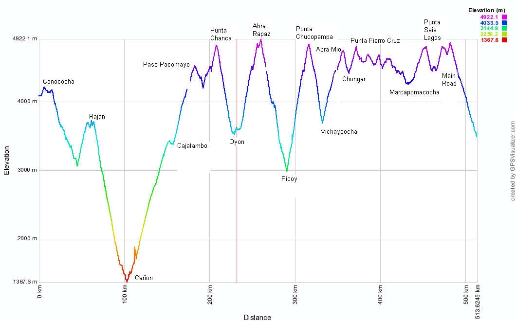
| The stats for the trip, which took us twelve days (with four half days): 472 km, 51 hours and 43 min at an average of 9.1 km/h |
Route notes:
- The Pikes´excellent
Andes by Bike website has all the information you need to do this incredible route. Read the comments made by other cyclists for more up to date details.
- As the route is mostly on high to very high ground, a good acclimatization is essential. In terms of food, there´s basic stuff at most villages, just don´t expect very fresh produce. Water was never a problem, although with the amount of herd animals everywhere on the route, we would approach every source (even at very high altitudes) with caution and treat/filter as necessary.