After we completed the first section of this magnificent route by the Pikes on Bikes, we knew only 350 km separeted us from the beautiful colonial town of Huancavelica, We´ve ridden distances like these in less than 24 hours many times as part of audax events in the UK...But again, km in the Peruvian cordillera doesn´t mean much. You are better off looking at the profile...
 |
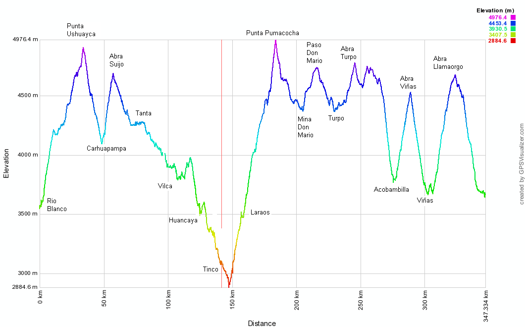
| Profile of the part 2, as taken from the Pikes´blog |
350 km and 7 passes over 4500 m was a much more accurate picture of what we had ahead. Then, Pete, the australian cyclist we had met a couple days earlier going North, had assured us that the scenery was nothing but incredible...and that he had also endured snow every day. With all that in mind, and a few chocolate bars in our frame bags (no cheese was to be found in the carretera central, unfortunately) we set off from Chicla...in the pissing rain. Below is our account of some of the best riding we´ve done in our cycling days. Indeed, Pete was so right...
 |
| We left the busy carretera central and took on the trails back up to our working altitude of above 4000 m. Initially we were faced with some steep sections, that then got slightly easier as we approached the abandoned town of Yuracmayo... |
 |
| ...where we were astonished to see a large group of mountain bikers come up to the laguna near this town... It turned out there were limeños who had driven all the way from sea level to 3700 m, then ridden up to Yuracmayo at 4300 m (some having real difficulties with the altitude, obviously!). Most were sporting shorts and summer clothes, so when rain and snow hit the area, they sought refuge in the only opened building in town: the security guards who looked after the represa (dam) gave all of us a dry place to shelter for a while. |
 |
| With snow hitting Yuracmayo hard at 2 pm, we thought it was best not to climb any higher, wait out the storm and continue the following day. Security guards William and Gerardo offered us to sleep in their hut, but most interestingly, kept us entertained with really fulfilling conversations about the present and past of Perú. We believe that speaking to locals is the best way of getting to know a country...we are as interested in the social issues of Perú, as we are in its incredible scenery |
 |
| In the morning, we set off towards the first pass Punta Ushuayca (4950 m) with a fresh layer of snow covering the mountains... |
 |
| The last few km to the top to the top of the pass were especially hard, but with such scenery, it did not matter that much.... |
 |
| ...then a muddy and rocky descent followed, before a sharp turn delivered us back to another steep section of bad, rocky surface up to Abra Suijo pass. |
 |
| And as we struggle with the climb, we saw Felix, a German tourists who was riding the same route as us in reverse. It appears the great divide of Perú is becoming more and more popular to travel from Huaraz to Ayacucho, as an alternative to the 3S (the Panamericana of the mountains) |
 |
| The climb to Abra Suijo saw Alberto feeling weak, and after many water stops to admire the views... |
 |
| ...we set up camp to continue the following the day with the remaining 400 m climb to the top. |
 |
| First thing in the morning we make our breakfast of oats, milk, and fruits. At 4400 m, the morning sun makes such a difference that we take our time... |
 |
| ...before continuing back up, where we see these amazing rock formations... |
 |
| ...then, at 4700 m and near the pass, we cycled past two beautiful lagunas, the second one with more nevados for background |
 |
| The following descent to the town of Tanta was quite rolling... |
 |
| ...passed some more lagunas (with their obligatory trout farms)... |
 |
| ...until we reached the red-roofed town of Tanta, where we had our lunch. The whole area is the Nor Yauyos Cochas reserve, free to access and with a few information offices scattered around - one such office is in Tanta. |
 |
| Going round the big lake near Tanta, we prepared ourselves for what comes next: the bike and hike! |
 |
| After a few gentle kms, we struggle to push the bikes through some steep sections of singletrack. This bike and hike avoids two big passes and saves about 35km on the way to Vilca, but it is not to be taken lightly... |
 |
| ...as it obviously takes much longer than expected...and so we camped at another idyllic location, near the river Cañete. |
 |
| Luckily, we are able to cycle some parts of the bike and hike, like this one, which remind Alberto of his good old mountain biking days |
 |
| The town of Vilca, at the end of the bike and hike, and its colonial "Centenario Bridge" is a welcome sight... |
 |
| ...leaving Vilcas, on one of the most scenic roads of our time in Perú, we are treated to some impressive vistas of the río Cañete´s lagunas |
 |
| Late in the afternoon we pulled into Huancaya (not Huancayo!), a touristy town for Peruvians that is empty during the week. The municipality runs a budget hospedaje and a tiny museum with about a dozen mummies, so we called it a day and enjoyed a hot shower. They also supply Lima with tons of trout, we guessed that´s why the trout statue in the main plaza? |
 |
| ...then the following morning we are treated to some paving! We love dirt, but a freshly paved quiet road is always a welcome sight, which gave us the sense of speed that we had long forgotten after so many days on the divide! |
 |
| Continuing on the paved road, we quickly gained altitude to Laraos, which is surrounded by impressive pre-inca terraces. In Laraos, after a yummy S/.5 almuerzo just off the main road, it was time to stock up for 2-3 days without any facilities. |
 |
| With heavier bikes, we pedalled on climbing away from Laraos... |
 |
| ...until the freezing afternoon rain caught up with us at 4300 m. Just before the storm, we had the perfect afternoon light. The following day we would be going into what looks like mordor here (to the right of the lit up mountain!) |
 |
| After the storm came the morning sun - it was time to dry all our kit |
 |
| At the turnoff with the Laguna Pomacocha, we diverted from the Pikes routesheet and went right, avoiding a potentially muddy climb and cutting the distance to Huancavelica short by 20 km. Although we have cycled the better part of 8 months without a routesheet, it still felt a bit nervewracking to leave behind the Pikes´notes! |
 |
| The climb was gentle at the beginning, but got incredibly steep in the last km, requiring both of us to push up more than 20% inclines...but check out those colors! |
 |
| The descent on the other side was typically peruvian, with tight switchbacks |
 |
| Another climb followed, this time with another range of nevados for company... |
 |
| ...and of course, some alpacas and llamas... |
 |
| ...each with their own unique style |
 |
| ...in fact, it was just like in the UK, as they were all queueing to get over the pass! |
 |
| After we left the queue of llamas behind, we enjoyed some ups and downs at 4500 m - we love altiplano riding! |
 |
| At 5 pm we set up camp by a laguna, just minutes before an electric storm spitted rain/hail/snow on us...not fun times as we strained to remember our lightning safety information from when we were kids. |
 |
| In the morning we climbed the gentle gradients of Abra Turpo, before dropping down to a lowly 3500 m... |
 |
| ...early afternoon in Acobambilla, our first resuply after some days of riding, where we got hit but heavy rain storm. We sought shelter in the municipalidad, where we were allowed to sleep in the office of the "Juntos" program. It gives support to the poorest people of rural Peru. |
 |
| Acobambilla suffered a devastating flooding in 2007, so most of the town is now built above the bridge and has few facilities. However, in the main plaza, there was Lea´s shop, selling the usual Peruvian grub, plus basic ingredients. She also cooks food upon request, and while waiting for it, we saw life go by: from kids selling freshly caught trucha, to a woman in excruciating pain asking Lea for advice on medicines, to an old man buying a month´s worth of flour and rice. |
 |
| As has become our custom, the following morning saw us on another climb. We passed villages where kids were eager to talk to us...The usual "where you came from, how far you ride, how many punctures" was followed by the eldest boy asking if he could buy Alberto´s bike and how much we wanted for it... |
 |
| As we kept climbing, we realised there was no way we could make it to last pass of the route and on to Huancavelica before dark, so found an ideal spot to camp, above the road and with a view of the entire valley. |
 |
| Then, as per usual, kept on climbing after breakfast and finally made it to the top of the last pass of this part of the Great Divide, Abra Llamaorgo (4700 m) |
 |
| The final descent into Huancavelica was of the fast and good surface type, an ideal way of finishing off what had been an amazing week of dirt riding. |
 |
| We hit Huancavelica (3700 m) on a Sunday, which meant feria day... |
 |
| ...and we couldn´t resist to try the local dish of lechón con chuño (pulled roasted pork with dehydrated potatoes - at the bottom)... |
 |
| ...and a river fish ceviche and chicharrón (fried fish, or pescaito frito if you´ve been to the South of Spain), with chicha morada (a drink made of purple corn) |
And that was the end of the Great Divide of Perú riding for us. The Pikes have another 700 km of route from Huancavelica to Santa Rosa (see
here and
here), but we did not have the time to ride them on this part of the trip.
Route notes:
- As with the previous post, all the information you need can be found on the
Andes by Bike website. Same as before, it is crucial to be well acclimmatised to tackle this route. Water was never a problem.
- The climb to Laguna Pomacocha and Mina Mario can be avoided by simply sticking to the "main" road, as described in the comments we made on Andes by Bike:
As an alternative to the Paso Punta Pumacocha and Paso Don Mario, we saved about 20 km by ignoring the instruction to turn L at 175.5 km 4300 m. It may be a good alternative if you are pressed for time like us, or if you want to be able to divert to the town of Atcas and carry less food. We don´t think you save that much climbing though (the first pass is slightly lower, also very steep, and the second a bit higher than the Pikes´ route). Here are our route notes if you do decide to take this alternative, from Pikes 175.5 km:
- Turn right instead of left signposted Mina San Valentín
- 4.4 km 4590 m go R signposted Heraldos Negros
- 9.7 km 4850 m High Point
- 17.3 km 4400 m Low Point, Cross bridge
- 18.6 km 4400 m go L/straight (R is for Atcas, a few km away slightly downhill and with at least a shop)
- 24.6 km 4820 m High Point
- 38.4 km 4620 m go L (signposted Puente Melliza). R would also return to the Pikes route via the main road, but will take longer and carries more traffic
- 40.3 km 4600 m sharp R, easy to miss
- 45.2 km 4460 m go R at the few houses rejoins Pikes´ route. There´s a water tap available.
- 46 km equals Pikes´ route 240 km
Inspiring account and great photos. Thanks for that.
ReplyDeletethanks for your note Frank - glad you liked it!
ReplyDeleteNow your previous comment about the rain makes sense- yikes! Your camp sites however look so beautiful and peaceful. It seems like you guys had a wonderful experience cycling this route!
ReplyDeleteThank You and I have a dandy supply: How Many Home Renovation Shows Are There whole home remodel cost
ReplyDelete